
“Okay, now if anything goes wrong, you’ve got to pull down hard on this door handle here, and then put your whole weight into it. Then climb out the door and on to the wing strut,” he said.

These were the words from our baby-faced pilot during a short safety briefing prior to a scenic flight in a seemingly ancient Cessna 182. We were preparing to fly from Burketown out to the mouth of the Albert River where it meets the waters of the Gulf of Carpentaria. It’s doubtful the advice would have been of much benefit to me. I was in the back seat. There is no door at the back. At least my husband would have had a fighting chance of getting out.

But of course, nothing did go wrong. In truth, I never expected it to. I had been in a similar light aircraft in Tasmania – a flight over Cradle Mountain – a long time ago; and I’d also once flown in a Tiger Moth over the Whitsunday Islands, out from Airlie Beach. And only a week before, we’d flown in a helicopter over Cobbold Gorge and an ancient geological formation called the Hampstead Sandstone (but I’ll tell you about that day in another blog post!)

But to marvel at a landscape from the air, to witness the grand scale of nature unfolding before you, is an astonishing privilege indeed. And Burketown, for all its dust and baked earth, sits in a truly sublime landscape. The traditional country of the Gangalidda People, the tiny settlement of Burketown and its surrounds, in the Gulf country of far north-western Queensland, is smack bang in the middle of a region of northern Australia that is considered to be the “largest intact savanna remaining on Earth”.1
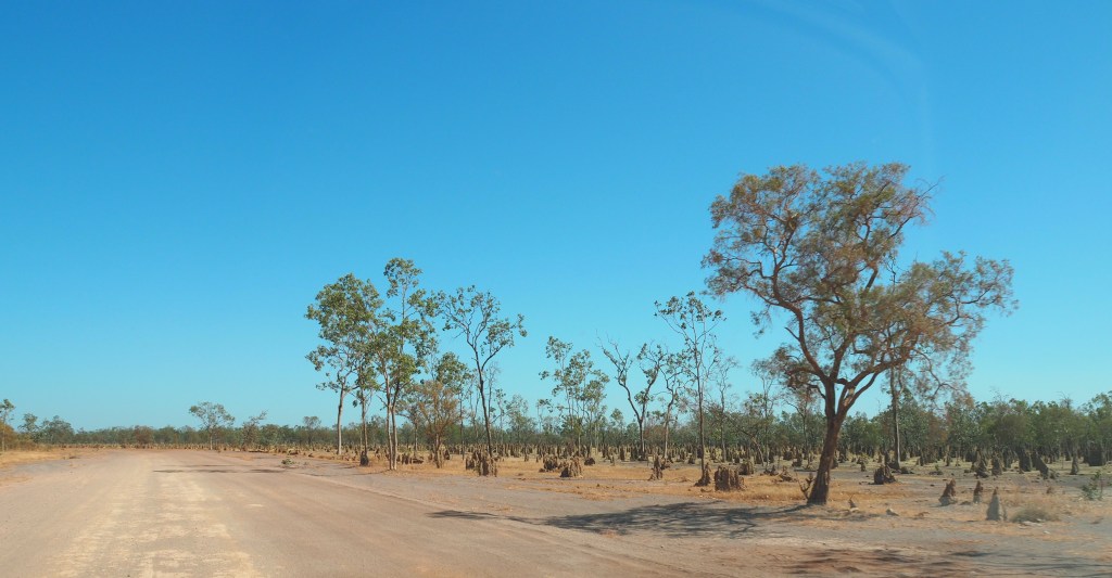
On the drive from Normanton to Burketown, we had driven for hours through what felt like endless savanna grasslands, stretching out in all directions as far as the eye could see. Flat, sparsely-treed plains of straw-coloured native grasses, the so-called “Plains of Promise”.2

But far from being “empty” (as some might see this landscape) we saw plenty of animal life here – mostly birds, and a few cattle. There were Wedge-tailed Eagles feasting on roadkill, a few brolgas, and lots of small birds – finches of some kind. And there were flocks of galahs that flew along in a leisurely fashion just in front of our car, acting as if they were guiding our way. The road itself was so quiet, we were able to slow right down when these came near, so we could get a good look at them. Oh, and I guess if you count ants as animals, we saw plenty of termite mounds. Sprawling out like small cities; thriving in this challenging environment through their own sheer cleverness.


(These photos of the Wedge-tailed Eagle were taken on the road from Burketown to Cloncurry. Both images © Trisha Fielding)
But back to Burketown… We taxied out to the runway, got up to speed, and take-off was smooth and light. Very quickly we began to understand just how vast the surrounding landscape around Burketown was. I’d had an inkling of how boundless it was when, earlier that day, we had visited the cemetery, the wharf on the Albert River, and the remains of a tree blazed by William Landsborough. But I doubt that anything could really have prepared me for how magnificent this place is.

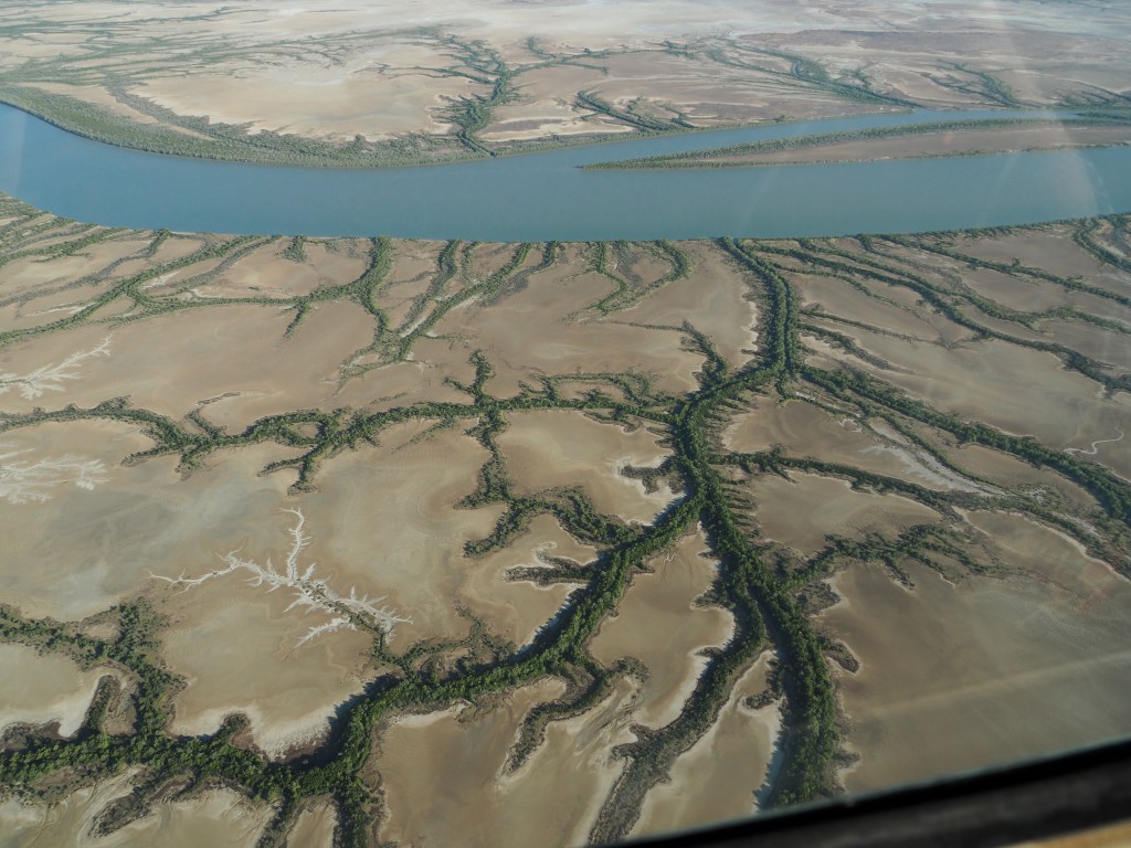
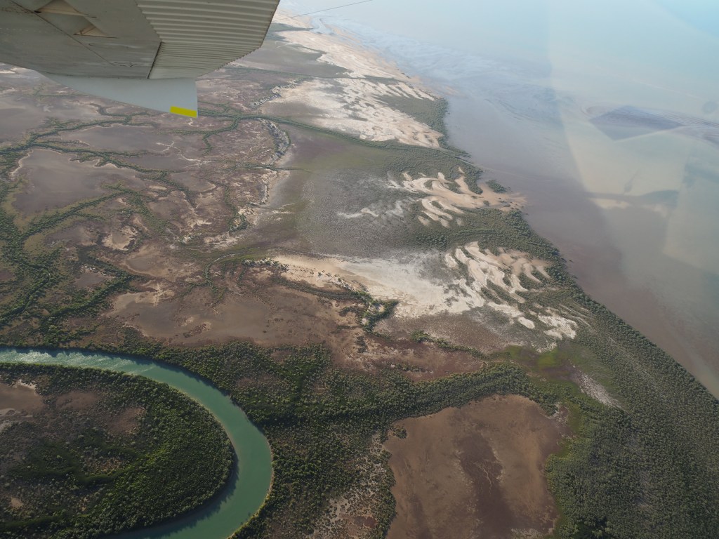
First, we got a birds-eye view of the town of Burketown, and soon we were soaring over endless saltpans, heading for the Gulf of Carpentaria. (The lower Gulf area, in which Burketown lies, has the largest aggregate area of saltpans in Australia. During the monsoon season, these form a wetland in excess of 2 million hectares). The Albert River, in all its magnificence, is a spectacular sight from the air. It looks like a blue-green coloured ribbon, winding round and round for 40kms, making its way to the Gulf all in its own good time. The entire river is thinly-fringed by mangroves, but at this time of year, everything else is just dusty saltpans.

Branching off from the river are thousands of narrow watercourses; little off-shoots looking for all the world like veins. Perhaps that’s what they really are – the very life-blood of this landscape. At times, the river and its mangroves twist around and back so much on itself, that the water in the river almost connects back up with itself – but not quite. What must this astonishing place look like during the wet season, I wondered? In some places, the water reflected the sun like sparkling little diamonds. It was glorious.
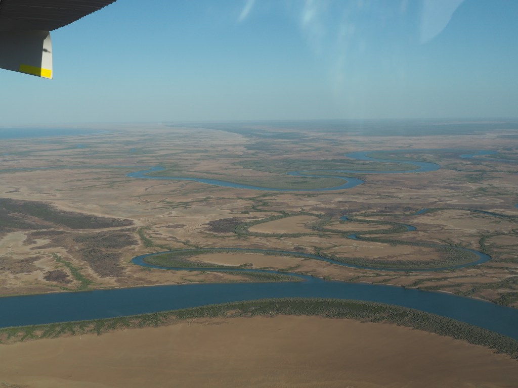
We floated along at a leisurely pace for about 25km before we were above the wide mouth of the Albert River where it empties into the waters of the Gulf. It was a majestic sight. We could just make out Sweers Island, shimmering like a mirage on the horizon. (As an aside, my great-great-grandmother was born on Sweers Island, in 1868. Again, probably a story for another day…)

From up here we could also see the mouth of the Leichhardt River, not too far off. But all too soon our pilot began to circle back. He pointed out another big river – the Nicholson River – snaking its way to the Gulf, just like the others. Northern Australia is said to retain “the largest expanses of intact rivers and catchments in the continent”.3 I can well believe it.
We had driven through the Leichhardt River on our way to Burketown a few days earlier, across a concrete causeway that seemed to take a few minutes to cross. Thankfully this was the dry season, or we’d never have been able to cross at all. This astonishing river has been known to rise to almost 12 metres during flooding events!
But I’ll never forget the sight of the Albert River from the air. I think I was awestruck. It was a thing of wonder. A green ribbon, winding its way through the landscape, giving life to everything it touched.

References:
- Woinarski, J. et. al. The nature of Northern Australia: it’s natural values, ecological processes and future prospects, ANU Press, Canberra, 2007, p. 85 ↩︎
- In 1841, Captain J. Lort Stokes of the Beagle, named these flat, grassy plains for their potential as rich pasturelands. ↩︎
- Woinarski, J. et. al. The nature of Northern Australia, p. 56 ↩︎
